July 17, 2009
We got the usual late start from Salt Lake headed to the target site. I always imagine a 7am lift-off and as usual, Mission Control imposes delays that cause us to leave at…9:30. Fortunately, it was a low-traffic day, so we made excellent time – about 6.5 hours to the lodge at the north rim of Grand Canyon.
The North Rim Lodge at Grand Canyon is excellent. It’s a bit overrun – as are all lodges in the National Park system are at this time of year, but the staff seems to handle it well. It has a pretty high energy level – much higher than say the Zion or Bryce lodges in Utah. I have a theory about this that I’m refining – more on this in a year or so.
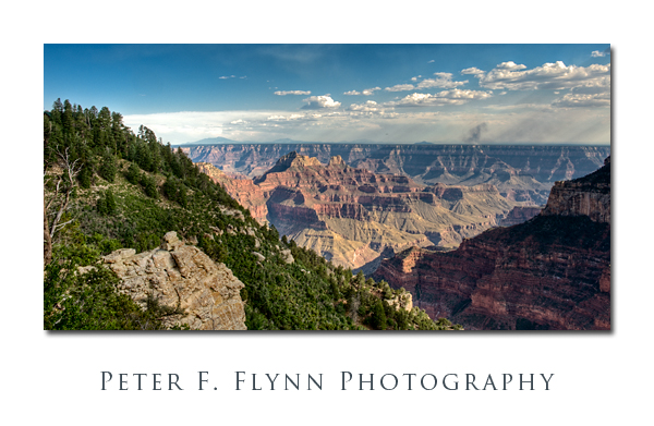
The view from the Lodge area, which encompasses Bright Angel Point and the adjacent Transept Canyon are just breathtakingly beautiful. Virtually all of the visitors congregate along the Lodge viewpoints and the viewpoints within about 100 meters of the Lodge. A short journey westward along the Transept Trail from the Lodge towards the terminus at the campground will provide some comfort space.
Yeah, so one major kooky thing about the North Rim Lodge is that you need porters to haul your gear from your truck to your room. It’s actually done pretty well, but it’s definitely an odd design issue. I mean, what if I wanna bolt in the middle of the night or something?!!! Okay, right, I’m most probably too tired to execute any such lively plans, but it’s still a thing that I’m certain could be better reconciled.
Some tests on this trip include a shakedown of the Nikon GP1 GPS unit and its requisite MC-DC2 shutter release. Wait, what? Oh yeah, although I have pretty much given up reading postings about Nikon gear, I imagine that people are royal-y pissed about having to buy yet another shutter release (unless you are a D90 shooter, in which case you probably already have that release). To be fair…wait, did I say…fair? Forget it folks, life is not fair, that’s the explanation of why we need yet another shutter release. Anyway, I’ll be putting the GP1+MC-DC2 on test. I’ll also be putting the much praised Hoodman UDMA CF 16GB card on test – dude, at $300 per specimen, it had better work well – no pressure though…
The HP and I walked along the Transept Trail and stopped at several spots to shoot some images. The pre-sunset sun was dodging in and out of clouds which meant standing around waiting for a bit between breaks. Bracketed a variety of 5, 7, 9 1/3 to full-stop increments in the hope of putting together some interesting HDR images later on. Like any canyon situation, the dynamic range here in the late afternoon is extremely high.
The Western Cabins are excellent – roomy and well made (no TV, internet, A/C or fan). These cabins all have porches with two chairs. Some of the porches overlook the canyon (cabins 305, 306, and 309) – apparently these choice cabins are booked years in advance (hey, there are always cancellations). Do not confuse the Western Cabins with the older Pioneer Cabins. The latter are an excellent option, but are much smaller and a little more rustical.
July 18, 2009
Woke up at sunrise and took a stroll down to Bright Angel Point and then back along the Transept Trail beyond the lodge. Very nice light. The head of the transept dominates the scene, with most of the remaining elements in the shade. Lot’s of folks about, and plenty of shooters – most out for a quick snap. Again bracketed shots in the hope of recreating some of the beautiful early morning scene in HDR.
Visited the General Store. It’s a solid stop – wine, beer, snacks etc. This establishment also offers the only public WiFi location within Grand Canyon North Rim (free). After perusing the lodge, Park Service Visitor’s Center and the General Store, I am convinced that no decent baseball caps or T-shirts are available – I believe this might be a lucrative business opportunity (seriously, if you’re into that area).
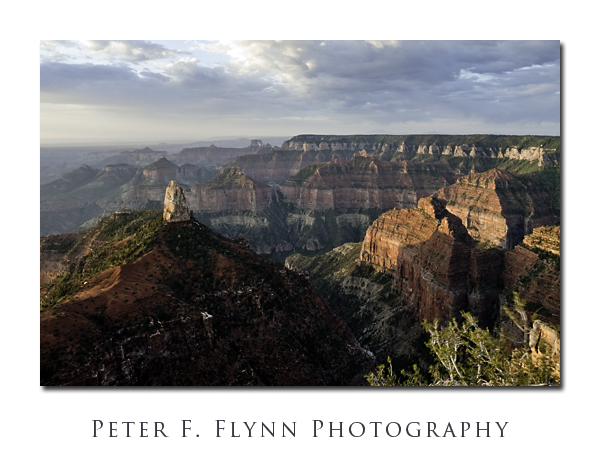
Headed toward Point Imperial (~8800 ft), and stopped to shoot IR images of Mount Hayden (~8400 ft) and Nankoweap Canyon at about 10:30 am Arizona time. We continued on directly to Cape Royal to shoot IR while before the sun ducked behind the increasing clouds.
A monsoonal pattern appears to be settling into the Grand Canyon area. Heavy clouds begin to dominate the southwestern skies starting at around 2pm Arizona time – by half past 3pm, the air has become hot and humid.
We had only one night reserved in the Western Cabins, and so we had to move into a motel room for the next two nights. While lacking the majesty of the cabins, these rooms are actually quite pleasant. They are sufficiently roomy for two people – much more than two and things may become uncomfortable fast. The commode area is sort of ridiculously small (weird!). The overhead room fan is an excellent notion altogether.
July 19, 2009
Woke up at dawn for a sunrise shoot at Point Imperial (went to bed early the previous night on account of there being no sunset shoot the previous evening). Met just two dawn-watchers at the point. Light was nice, although perhaps a bit muted. A light but persistent breeze blows across the point, which means that all of that greenery in the foreground (inevitable) is gonna be pretty blurry.
On the way back to the motel we encountered the pretty-elusive Kaibab squirrel. As the critter ambles across the road in front of us, sez me, ‘Heya, that’s a skunk…no wait, no, it’s a Kaibab squirrel!!!’ Picture time. Stopping the truck post haste, we monitor the squirrel, trying to get a shot, but the little bugger runs off. Dang, no documentation. Dude, these are the coolest squirrels ever – okay, cool + squirrel does not add up, buy anyway they are beautiful. They have these sinister-looking tufts of hair on their ears, but the best bit is that they sport a white tail! No, but they have white tails!!! Amazing adaptation – guess it’s a plus in the survival/reproduction column to look kinda like a zorrillo – who knew?!!!
Began a hike down the North Kaibab Trail to Supai Tunnel at ~8:30am (Arizona time). Cool at the start, but temperatures rise very rapidly in the canyon. The scenery down the trail gets a 9/10 for general hiking sort of thing, and a 7/10 photographically-speaking on account of the fact that you gotta wait for stark light to fill the depths of the canyon to grab your shot…
An important stop on the way to Supai is Coconino Point. This is an excellent place to rest on the way down – BTW, if you’re resting on the way down, you’ll have just a grand time a bit later on… Anyway, this is the place for shots down into Roaring Springs Canyon. The Supai Tunnel itself is interesting in terms of the engineering and labor that must have been invested to get the job done, but rather modest in terms of the photographical potential.
Warning: Anyone attempting a hike down the canyon along the Kaibab Trail is advised to bring nose-plugs. Huh? I’m not kidding; the excrement of the pack-animal (the Mule in this instance) seems to have been exported fresh from the bowels of hell itself. Okay, I see that you underestimate my advice – so, if you’re so tough, try this experiment at home – in the hottest part of the summer… Find a proper long flight of stairs in the direct sun. Prepare a bucket of ammonia water and leave it at the bottom…no, at the top of the stairs. If you can get a swarm of flies to live in the bucket you get extra credit. Run up and down the stairs a bunch of times until you git all weezy, and then stick your head in the bucket and breath deeply. If you survive, you live to write a blog entry – we’ll politely remove you from our frequented-list if things don’t go so well
After surviving the Supai Tunnel torture-test, we headed back to Point Imperial for more IR shooting. Unfortunately, by then the clouds were covering much of the sky, rendering IR imaging pretty weak.
July 20, 2009
We met an excellent sunrise at Cape Royal. The place was completely deserted. There was beautiful light on the foreground side of Wotan’s Throne, as well as on the backsides of Vishnu Temple and Krishna Temple. Again, the winds are very high at sunrise – anchor your support gear!

