Archive for the ‘Black Bear’ Category

Encounter at 2K8 (Hellroaring Trailhead)

PFF_D7100_20130515_0540_v2_Framed

I’m not much for novelty photography.  Let’s say that there is a bear dancing the ‘Macarena’ in the middle of the Yellowstone picnic area – I’d wait for the bear to stop dancing before beginning to shoot – okay, perhaps that’s a bit of an exag, but I’d run shots only if the bear was dancing real good…

The story behind the image above begins, as so many of the posts on this site does, with the HP.  The HP has two major roles – she is 1st and foremost, the transporter-extraordinare, getting us into position for the shoot – her less-well-known but equally important role is as chief intelligence officer.  Yeah, without intelligence you will be lost in the vastness of The Stone.  Right, I did mention Hellroaring…that’s in The Stone (as in Yellow-Stone, git with it people!).  Anyway, winning is about knowing where you need to go, and getting there before the plebes arrive, invariably screwing things up so that the NPS has to close the show down.

It’s around noon on May 15, 2013, and we are near the outlet of the Blacktail Plateau Drive, at the end of a bear-viewing event.  I see the HP hanging with Mr. Ranger-Sir and some folks with things to share.  The HP is in intelligence-gathering mode – looks kinda like a cat stalking prey…  She gets a tidbit, turns, and heads for the truck – time to go boys!  Nearly leaves one of us in the dust, damn this must be good.  Hellroaring, black bear, cub.  Dood, we’ve visited Hellroaring dozens of times and not seen a damned thing…  No point in arguing, the HP is set on course, we are off for Hellroaring.

PFF_D7100_20130515_0534_v2_Framed

Arriving at the 2K8 parking lot, we scramble gear together and head down the path.  Wait, okay, back up…some (most) of you have no idea what I’m talking about.  First, let me clarify that every trail in The Stone has an official designation – trailheads are distinct from paths.  The designator 2K8 is specific for the trailhead for a number of trails leading into the Yellowstone River and Hellroaring Creek basin.  These paths include, 2H1, 2H2, 2H3, 2H4, 2H5, 2H6, 2H7, 2H8, 2H9, 2C1, 2C2, 2C4, 2R1, 2R2.  The 2K8 also provides access to the backcountry trailheads 2N1 amd 2N5, which are located north along the Gallatin NF/Stone boundary.  The key point is that 2K8 is directly in the middle of the action.

PFF_D7100_201305415_0537_Framed

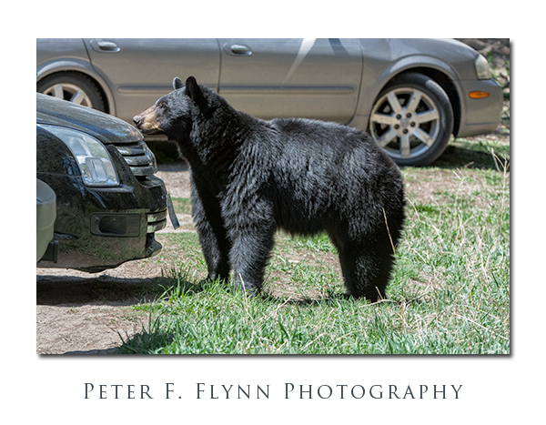
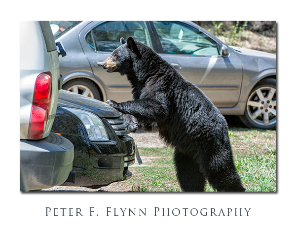
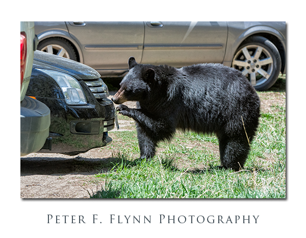
We march out along the trail headed east and pretty-much run squaw into a black bear sow with a yearling cub.  The cub is instantly up a tree and momma bear is keenly intent on keeping us at a distance.  In standard black bear behavior, this sow wanders slowly up the trail, backing everyone up into the parking lot.  Once in the parking area, the sow decides that a vehicle inspection is the order of the day.

PFF_D7100_20130515_0539_Framed

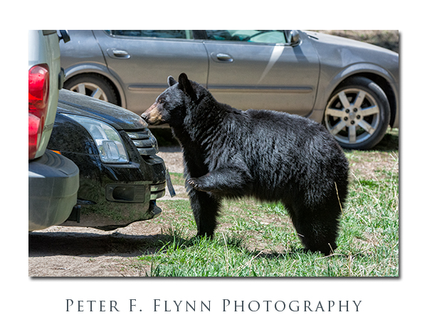
In the end I think it’s bugs.  Dead bugs.  On the license plate.  Illinois plate, plenty of bugs.  I guess the idea is that given plenty of dead bugs on the plates, there must be more on the hood.  In the end, the sow fended off the infidel-humans.  The humans got their photo-op.  Rangers and plebes alike had no idea about what happened here – kinda like Vegas actually, what happened here, stayed here…

Some of you may be wondering what the Macarena is…  Substitute Charleston, Bossa Nova, Mashed Potato, Tejas 2-Step, Worm, Cha Cha Slide, Crank That Soulja Boy, Single Ladies, Dougie, etc., depending on your age.

All images in this entry were recorded on May 15, 2013, at around 12:00, using the Nikon D7100 and the AF-S NIKKOR 200-400mm f/4G ED VR II.  Exposure was f/8.0 and 1/640s, ISO 2000.

Copyright 2013 Peter F. Flynn.  No usage permitted without prior written consent. All rights reserved.

NE Entrance Road

The NE Entrance Road is one of the major thoroughfares of Yellowstone National Park, linking Tower Junction to the southwest and the northeastern park boundary.  From its western terminus at Tower Junction, the road heads northeast about 0.75 mile to the bridge over Yellowstone River.  The road turns to true east after the bridge.  The road then tracks along the Yellowstone and Lamar Rivers at the base of Specimen Ridge to the bridge at about 4.5 miles, and then another 0.6 miles to the junction with the road leading to Slough Creek Campground.  From the campground, traveling east another 0.75 mile brings you to the west end of Lamar Canyon.  The length of the canyon is about 1 mile, and opens at the east end to the broad expanse of the Lamar Valley.  The road then heads southeast along the Lamar River for 2.75 miles to the Yellowstone Associate Camp, and then another 2.8 miles to the confluence of the Lamar River and Soda Butte Creek.  The confluence of the Lamar River and Soda Butte Creek is a major park reference point, and both rangers and park cognoscenti refer to the location as ‘The Confluence’.  From here to the park boundary the road runs alongside Soda Butte Creek.

Assuming that you are coming from points west, and after passing through the Lamar Valley, it is just when you think you have left Yellowstone’s geothermal features behind that you run nearly right in Soda Butte at 2.3 miles east of The Confluence.  This extinct cone is just a few feet south of the road.  This is where we associate the story with images.  The image above was shot at a turnout about a half mile southwest of Soda Butte (1.8 miles east of The Confluence).  There is a minor stream here that drains the high ground to the north into Soda Butte Creek.  The relatively abundant water supports the growth of Chokecherry and other leafy plants, generating a stark contrast again the pale green of the sage.  The image was recorded at 11:30 MDT on October 16, 2011, using the Nikon D3s and the AF-S NIKKOR 16-35mm f/4G ED VR at 23mm.  Exposure was f/11 at 1/25s, ISO 200, +0.33 EV.  A dark and mostly rainy day.  The image was processed using Photoshop CS5 with Nik Viveza 2 and Color Efex Pro 4 plugins.  Capture and output sharpening was applied using Photokit Sharpener 2.

A Google Earth image of the location appears below:

Traveling northeast along the road brings you, after 3.3 miles, to the Pepple Creek Campground, the last camping spot along the road. After traveling another 1 mile you will arrive at the Thunderer trail head (3K3) parking lot and the entrance to Soda Butte Canyon.  Soda Butte Canyon is tucked in between the Barronette Peak to the northwest and The Thunderer massif to the southeast.  The road continues through Soda Butte Canyon, coming after about 1.5 miles to the narrow Icebox Canyon.  There is a very nice picnic spot just at the northern end of Icebox Canyon – we saw a small Griz on the far side of the stream here in the early spring of 2011.  The road continues through Soda Butte Canyon reaching the WY state line at about 5.8 miles further, and the park station at about 2 miles beyond the state line crossing.

This region of the park is home to many animals, including both Black Bear and Griz, but because of the relative steepness of the canyon walls on either side, the wildlife is only visible when they are basically right along the road.  This situation presents a minor hazard, since it is possible to encounter Griz with relatively little advanced warning.  If you stop along the road here, I strongly advise you to keep your bear spray close at hand.  On this visit was were fortunate to catch a glimpse of a Black Bear foraging along the north side of the road.  The location was approx 100 meters northeast of the turnout for the Thunderer Trail.  We were able to watch this bear for about 30 minutes before it wandered off into the dense forest. I have come to notice that Black Bear rarely look directly at me, and perhaps even avoid direct eye contact.  Many species consider eyes-on to be a threatening gesture, and I suspect that Black Bear are quite adept at avoiding conflict.  This behavior is quite distinct from that of Griz, which will tend to keep a steely bead on you at all times.

Images of the Black Bear were recorded at around 17:30 MDT on October 16, 2011, using the Nikon D3s and the AF-S NIKKOR 200-400mm f/4G ED VR II at 400mm.  Exposure was f/4.0 and 1/125s to 1/200s, ISO 6400.  Yeah, here as in many posts, these images are possible because the D3s + VR exist.  The noise is actually pretty modest, but the color noise components were reduced using Nik Dfine.  Additional processing was applied using Nik Viveza 2 and Color Efex Pro 4 and Photokit Sharpener 2 plugins.

Copyright 2011 Peter F. Flynn.  No usage permitted without prior written consent. All rights reserved.