 On a recent visit to the eastern Sierra town of Mammoth Lakes, I had the opportunity, nay pleasure, of making several short sorties to the South Tufa area of Mono Lake State Natural Reserve. Mid-November is perhaps not the most obvious time to visit, but the weather moving through the region during the late fall of 2012 made for compelling skies.

The story of the Mono Basin is legend amongst the environmentally aware… A lake forsaken to quench the thirst of the City of Los Angeles, only to be saved (apparently) through the efforts of many, culminating in the historic court case between the National Audubon Society versus Superior Court.
In 1941, an increasingly thirsty City of Los Angeles began systematically diverting water flowing into Mono south towards the city water supply. The lake level at the beginning of the diversions was 6417 ft above sea level (asl), with a lake volume of 43 million acre-ft, and this level establishes the condition of no exposed lakebed. The diversion continued unchecked for four decades, and by January of 1982 the lake level had fallen to 6372 ft asl (a change of 45 ft), losing just of half of the original lake volume, and exposing over 18,000 acres of lakebed.

As of October, 2012, the lake level was 6382.4 ft asl (LA DWP). The current lake level target is 6392 ft asl (as mandated by the State Water Board in 1994). The tufa formations along the South Tufa Trail range to about 20 ft above the current lake level, so much of what is currently visible will be covered by the additional 10 ft of water.
The four images above were recorded on the afternoon of November 14, 2012, using the Nikon D800E and the AF-S NIKKOR 24-70mm f/2.8G ED lens at various focal lengths. Exposures were f/8.0 or f/11.0 and 1/500s to 1/100os (+0.33 EV, corrected in raw conversion), ISO 400.

The next day I arrived at the South Tufa area at 09:00 PST. The air was crisp and clear and the light was winter cool. The image above and the three that follow below were shot look east towards Mount Dana and Mount Gibbs.


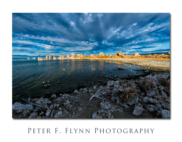
All of the images (save one) in this entry were recorded from along the southern shore of Mono Lake in the South Tufa Area. To get there, depart US 395 5 miles south of Lee Vining, and travel northeast for 4.7 miles along Mono Basin Road (CA 120). Turn left (north) onto Test Station Road and travel another mile to the South Tufa parking lot (fee required). A boardwalk leads from the parking area to the southern shore of the lake. Here you will find the most extensive tufa formations.

The image above is typical of the sort of scenery visible from along the boardwalk. The three images below were shot looking north across the lake. The angle of the sun in the late fall morning is perfect for capturing the eastern side of the South Tufa Area.


The eight images above were recorded on the morning of November 15, 2012, using the Nikon D800E and the 24-70mm lens at various focal lengths. Exposures were at f/11.0 and 1/800s (+0.33 EV), ISO 800.
The image below was recorded from Mono Basin overlook off of US 395, located about 0.2 mile south of the West Portal Road. This image was recorded looking northward at 12:30 on November 16, using the Nikon D4 and the 24-700mm f/2.8 lens at 60mm. Exposure was f/16.0 and 1/500s, ISO 1250.

The three final images were shot at the South Tufa Area later that same day using the same setup as described above. Exposures were f/8 or f/11 with shutter speeds between 1/400s and 1/800s, ISO 1000.

The image above was shot looking north, whereas the image below was shot towards the setting sun in the southeast.

The final image was shot looking towards the northwest in wanning light.

For more information about the natural history of Mono Lake consider the following resources:
http://www.parks.ca.gov/?page_id=25164
http://www.monolake.org/about/stats
http://www.monocounty.org/mono-lake/
Copyright 2013 Peter F. Flynn. No usage permitted without prior written consent. All rights reserved.
Tags: Eastern Sierra, Mono Lake, Mono Lake Tufa SNR, South Tufa Trail
The light and clouds were working with you this day. Seemed like a super crisp day for sure. You captured the area very well. Does the water have a high mineral content, even salty? All that white on the rocks makes me think so. If so, I would think that presented challenges for those wishing to drink it. Good work.
Hi B,
Yes, although there a big blue sky on the morning of November 15, the clouds were out in force. Mono lies in an endorhetic basin, which means it has no outlet to the sea. Thus, salt accumulates in the lake. Mono is a ‘three-salt’ lake, containing carbonate, chloride, and sulfate salts. In practical terms, the concentration of salts in the lake is about 8% (wt%) which is just a bit more than 2x as salty as the ocean (3.5%). The lake is alkaline, with a pH of around 10. By comparison, the Great Salt Lake is more variable, with a salinity range in the northern end of around 28% (Gunnison Bay) to a lower value of around 11% in the southern end (Gilbert Bay). The pH of the Great Salt Lake is also variable, but around 10.
P.