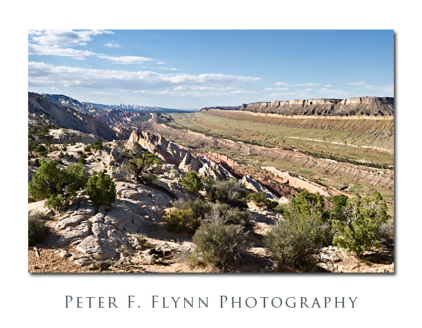
One of the highlights to a visit to Capitol Reef National Park is a drive south along the Notom-Bullfrog Road (NBR). The NBR heads south-southeast from the junction with Utah Highway 24 (about 9 miles east of the Visitors Center), and slips along the margin between the Waterpocket Fold and Strike Valley. At about 34 miles from the junction of the NBR and UT24, you reach a junction that heads westward up the Burr Trail Switchbacks. A short drive west from top of the switchbacks brings you to the Upper Muley Twist Road that heads north along the Waterpocket Fold. From the end of the road a short hike eastward brings you to a world-class perch, the famous Strike Valley Overlook – seriously, I’ve walked all over the west, this may be THE place.
To be precise, a ‘strike valley’ is a common geological formation found most anywhere immediately adjacent to a significant fold or upheaval. What we are talking about in this entry however is among the best examples found anywhere. This strike valley runs along the southern portion of the Fold from Cedar Mesa Camp about 11 miles south of UT 24 to the southern margin of the Park. The overlook grants views of the Strike Valley north and south along the Waterpocket Fold, and east to the Henry Mountains.
The image above was recorded at 18:00 MDT on July 24, 2010, using the Nikon D3s and the NIKKOR AF-S 24-70mm f/2.8G ED lens at 42mm. Exposure was f/16 and 1/200s (+0.33EV), ISO 400. Coordinates of the site are 37,52.9900N/111.2.5372W.
The overlook may also be reached from the west, by traveling east 26 miles out of Boulder, UT. The Burr Trail Road is paved from Boulder to about 5 miles before the switchbacks. On this visit we executed a loop trip back along this route to Boulder, and then north to Torrey, UT, along the magic UT Highway 12.
A few important suggestions. It would be an excellent idea to stop by the Visitors Center and chat with the staff about road conditions. Be aware that Park Staff are programmed to speak from a ‘better safe than sorry’ perspective, however this truly is a remote region with no water, and challenging driving conditions. The NBR is paved for the first 5 miles south from the junction with UT24, and then converts into dusty washboard south of that point. As is true most everywhere in south-central UT, roads in wet to very wet conditions are impassable, as in if you attempt to move you will slide off of the road, or become stuck in thick mud. The Burr Trail switchbacks are steep, but perfectly safe in dry conditions – they might be a bit of thrill for those with little backcountry driving experience. The Upper Muley Twist Road cannot be safely navigated by a low-clearance vehicles, although 4WD is probably only necessary in wet conditions. I also predict that very large pickups and wide vehicles (think Hummers) will have to execute some tricky moves to make it to road’s end (we drove a Toyota Tacoma with the crew-cab and associated short-bed).
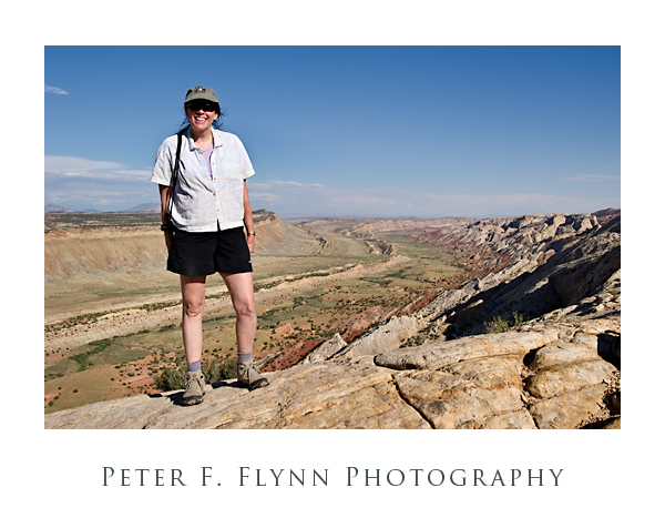
Finally (below), a shot of The HP, and the southern view into the Strike Valley. The image was recorded using the D3s and the 24-70mm lens at 32mm. Exposure was f/16 and 1/400s, ISO at 400. Handheld. You could not deduce it from her calm and relaxed appearance in the image, but the HP was the most awesome support ever – carrying a 20lb camera bag and tripod while chasing a panicky photog back and forth along a 200 meter section of the Fold in the failing light.
Copyright 2010 Peter F. Flynn. No usage permitted without prior written consent. All rights reserved.
Tags: Burr Trail, Capitol Reef National Park, Cedar Mesa Camp, High Priestess, HP, Notom-Bullfrog Road, Strike Valley, Strike Valley Overlook, The Fold, Upper Muley Twist Road, UT12, UT24, Waterpocket Fold


Looks like a great area, and hats off to the HP for her support. Might I suggest you reward her for those efforts. Perhaps a gift is in order to keep her motivated for other requests to carry the gear or long lenses. Going back in geological time, it looks like that area was home to a huge river. Do you think it held one long ago, or is it just an assumption based on looks.
Hi B,
Thanks for checking in. The theory of strike valley formation emphasizes compensatory folding rather than weathering. The shape of the valley – from a view orthogonal to the long axis of the feature – would appear as a semicircle rather than a V-shape , consistent with terra-forming as opposed to a dominant weather (river) influence.
Cheers,
P.
This is among the nicest renditions of the Strike Valley I have seen, congrats. Though to my eye this place begs for a nice star trail photo with about a quarter moon to light up the foreground. Though I understand the logistical problems of executing such a shot.
Hi Wade,
Thank you for your message. This is one of those spots that I’ll be returning to time and time again. Really a magic perch up there. I also like your suggestion for a nighttime shot, that would excellent – driving back out on the Muley Twist road would be fun in the dark, so I’d most probably stick it out until dawn. This begs the question (thinking now of park regulations): if I don’t have a tent set up, am I camping?
Cheers,
P.